
Thai Sky Vision

A New Standard for the Commercial Drone Industry

15 km Max Transmission
55-min Max Flight Time
6 Directional Sensing &
Positioning
Primary Flight Display
Hot-swappable Battery
IP45 Rating
-20°C to 50°C Operating Temperature
UAV Health Management System

Superior Performance
Improved Transmission System
The all-new OcuSync Enterprise enables transmission up to 15 km away and supports triple-channel3 1080p video. Real-time auto-switching between 2.4 GHz and 5.8 GHz4 enables more reliable flight near high-interference environments, while AES-256 encryption offers secure data transmission.
15 km
Transmission Range
1080 p
Triple-channel Video
2.4 /5.8 GHz
Real-time Auto-switching

Enhanced Flight Performance
The refined airframe and propulsion system design gives you a more efficient and stable flight, even in harsh conditions.
55 min
Max Flight Time
15 m/s
Wind Resistance
7 m/s
Max Descend Speed
7000 m
Service Ceiling
23 m/s
Max Speed

Multiple Payload Configurations
Configure your M300 RTK to fit your mission needs. Mount up to 3 payloads simultaneously, with a maximum payload capacity of 2.7 kg.
 Single payloadSingle Downward Gimbal |  Double payloadsSingle Upward Gimbal x Single Downward Gimbal |  Three payloadsSingle Upward Gimbal x Dual Downward Gimbals |
|---|

Advanced Intelligence
Smart Inspection
AI Spot-Check
Automate routine inspections and capture consistent results every time. Onboard AI recognizes the subject of interest and identifies it in subsequent automated missions to ensure consistent framing.ncryption offers secure data transmission.
Live Mission Recording
Record mission actions such as aircraft movement, gimbal orientation, photo shooting, and zoom level to create sample mission files for future automated inspections.
Waypoints 2.0
Create up to 65,535 waypoints and set multiple actions for one or more payloads, including 3rd party ones, at each waypoint. Flightpath planning is also optimized to maximize flexibility and efficiency for your missions.
PinPoint
Mark an object in camera or map view with a quick tap, and advanced sensor fusion algorithms will immediately calculate its coordinates, which are projected to all camera views as an AR icon. The location of the subject is automatically shared with another remote controller, or to online platforms such as DJI FlightHub.
Smart Pin & Track
Smart Track
Identify and follow moving subjects like people, vehicles, and boats with the Smart Track function, where auto-zoom is applied for steady tracking and viewing. The subject’s dynamic location is continuously acquired and shared to another remote controller or to DJI FlightHub.
Aviation-Grade Situational Awareness
The M300 RTK adopts a new Primary Flight Display (PFD) that integrates flight, navigation, and obstacle information to empower the pilot with exceptional situational awareness.

Flight Information
Flight information such as aircraft attitude, altitude, and velocity, as well as wind speed and wind direction, are all intuitively presented.

Navigation Display
Pilots can also view the live status of the aircraft’s heading, trajectory, PinPoint information, and home point projection, in a more efficient way. Visualize all nearby obstacles at once with the new obstacle map, so you can be fully informed.
Advanced Dual Control
Either operator can now obtain control of the aircraft or payload with a single tap. This creates new possibilities for mission strategies as well as higher flexibility during operations.

Safety and Reliability
A Powerful Vision System You Can Rely On
To enhance in-flight safety and aircraft stability, dual-vision and ToF sensors appear on all six sides of the aircraft, offering a maximum detection range of up to 40 m, with options to customize the aircraft’s sensing behavior via the DJI Pilot App. Even in complex operating environments, this 6 Directional Sensing and Positioning system helps keep the aircraft and the mission safe.


Redundancy Systems for Safer Flights
The M300 RTK’s built-in advanced redundancy systems help keep your critical missions going even in unexpected scenarios.

More Adaptable Than Ever Before
IP45
Anti-Collision Beacon
Self-Heating Battery
AirSense ADS-B Receiver
-20°C to 50°C
Flight Time
Estimate your M300 RTK’s flight time based on the payload configuration.

Compatible Payloads
.png)


.png)
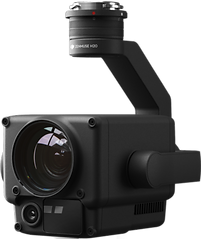
Dual-sensor camera with a 4K visual sensor and thermal imaging with <50 mK sensitivity
Zenmuse XT2
.png)
Zenmuse Z30
30× optical zoom camera ideal for detailed inspections
