
Thai Sky Vision
บริการโดรนตรวจสอบโครงสร้าง
Drone Structural Inspection Service
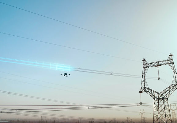
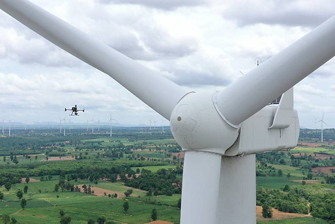
เราให้บริการงานตรวจสอบด้วยอากาศยานไร้คนขับ (โดรน) ไม่ว่าจะตรวจสอบแผงโซลาร์เซลล์พื้นที่ขนาดใหญ่ ด้วยโดรนและ AI, งานตรวจสอบกังหันลมด้วยโดรน, งานตรวจสอบเสาส่งสัญญาณไฟฟ้าด้วยโดรน ทางไทยสกายวิชั่นใช้อุปกรณ์คุณภาพสูงในการตรวจสอบ ได้แก่ LiDAR, Full Frame Camera, Thermal Camera ที่ทำงานร่วมกับ Matrice 300 RTK, Matrice 350 RTK , INSEE VTOL Fixed-Wing, และ Atmos Marlyn Cobalt VTOL Fixed-Wing
We offer unmanned aerial vehicle (UAV) inspection services for various applications, including large-scale solar panel inspections with drones and AI, wind turbine inspections with drones, and electrical transmission tower inspections with drones. Thai Sky Vision uses high-quality equipment for inspections, such as LiDAR, Full Frame Cameras, Thermal Cameras, which work in conjunction with platforms like Matrice 300 RTK, Matrice 350 RTK, INSEE VTOL Fixed-Wing, and Atmos Marlyn Cobalt VTOL Fixed-Wing.


ประโยชน์ของการทำงานตรวจสอบด้วยโดรน
-
ประเมินสถานะของทรัพย์สินได้อย่างง่ายดายโดยไม่ต้องเสี่ยงต่อความเสี่ยงหรืออันตรายที่อาจเกิดขึ้นจากการเข้าถึงที่ลำบาก
-
ลดค่าใช้จ่ายและเพิ่มประสิทธิภาพในกระบวนการเก็บข้อมูลด้วยการใช้โซลูชันการเก็บข้อมูลทางอากาศที่ง่ายต่อการใช้งาน
-
เก็บรวบรวมข้อมูลแบบเรียลไทม์เพื่อให้สามารถตอบสนองต่อสถานการณ์ที่เปลี่ยนแปลงได้อย่างรวดเร็วในการดำเนินงานของธุรกิจด้านการทำเหมือง
-
มอบมุมมองที่ได้จากอากาศที่สูง ซึ่งช่วยให้สามารถตรวจสอบทรัพย์สินที่ตั้งอยู่ในพื้นที่ที่ยากต่อการเข้าถึงได้ดีขึ้นและมอบการตรวจสอบที่เป็นรูปธรรมมากขึ้น
Advantages about Drone Inspection
-
Easily evaluate assets status, significantly streamlining data collection process.
-
Reduce cost and improve efficiency with easy-to-deploy aerial data collection solutions.
-
Collect real-time data, enabling mining operations to respond quickly to changing situations.
-
Aerial perspective allows you to view assets located difficult areas, offering a more comprehensive inspection.


Asset Inspection
ปรับปรุงประสิทธิภาพการตรวจสอบสินทรัพย์ด้วยการรวบรวมข้อมูลด้วยภาพและความร้อนโดยไม่กระทบต่อการปฏิบัติงานที่กำลังดำเนินอยู่
Improve asset inspection efficiency with visual and thermal data collection without disrupting ongoing operations.
Solution

Automated Remote Asset Inspection Solution
Deploy DJI Dock 2 at the mining site, and use the DJI FlightHub 2 as the control platform to remotely conduct on-site inspections and surveys. The mission progress is broadcasted live and the data can be synchronized to the cloud in real time.
Fully automated drone missions ensure consistent and regular data collection without the need for constant human oversight.
Minimizing the labor and time traditionally required for manual drone operations results in substantial cost savings.
Equipped with a high-accuracy mapping camera.
Easy to deploy and maintain,and can be operated normally even in high temperature, severe cold, high altitude and heavy rain environments.
Drone Platform

DJI Dock 2
Weight: 34 kg (without the drone).
Size: length 570 mm, width 583 mm, height 465 mm.
Environment Adaptability: -25℃-45℃ working temperature, IP55 Rate, max operation height 4,000 m.
Max Operating Radius: 10 km.
Payload And Software

DJI FlightHub 2
Drone and dock's cloud management system
Workflow
-
Data Collection: Plan a rountine mission for specific asset inspection or to navigate operation area.
-
Data Processing: Automate DJI FlightHub 2 data processing for 3D models.
-
Data analysis: Utilize DJI Terra or third-party software for AI analysis.

Matrice 3TD
Weight: 1410 g.
Size: length 335 mm, width 398 mm, height 153 mm (without propellers).
Max flight time: 50 minutes.
Max Operating Radius: 10 km.
Wide camera: 1/1.32'' CMOS, 48MP. Tele camera: 1/2' CMOS, 12MP.
Thermal camera: super resolution mode 1280 × 1024@30fps.
Environment adapbility: -25℃-45℃ working temperature, IP55 Rate, max operation height 4,000 m.


โดรนสำรวจระดับมืออาชีพจาก DJI Enterprise แม่นยำ เร็ว ประหยัดต้นทุน
โดรนสำรวจระดับมืออาชีพจาก DJI Enterprise – แม่นยำ เร็ว ประหยัดต้นทุน
ในการสำรวจและทำแผนที่เชิงวิศวกรรม ความแม่นยำและประสิทธิภาพคือหัวใจสำคัญ โดรนสำรวจจาก DJI Enterprise ได้รับการออกแบบมาเพื่อตอบโจทย์งานสำรวจที่ต้องการข้อมูลละเอียดระดับเซนติเมตร ด้วยเทคโนโลยี RTK (Real-Time Kinematics) และเซนเซอร์ขั้นสูง เช่น กล้องความละเอียดสูงและ LiDAR ที่ช่วยให้สามารถเก็บข้อมูลภูมิประเทศ 3 มิติได้อย่างแม่นยำ นอกจากนี้ โดรนสำรวจยังช่วยลดเวลาในการปฏิบัติงานภาคสนาม เพิ่มประสิทธิภาพและลดต้นทุน เมื่อเทียบกับการสำรวจแบบดั้งเดิม
สำหรับงานสำรวจที่ต้องการ ความคล่องตัวและแม่นยำสูง DJI มีตัวเลือกที่ตอบโจทย์ทุกความต้องการ เช่น
-
DJI Matrice 4 Series โดรนสำรวจรุ่นใหม่ล่าสุดที่มาพร้อมกับประสิทธิภาพที่เหนือกว่า รองรับเซนเซอร์หลากหลายประเภท พร้อมการเชื่อมต่อ RTK สำหรับการสำรวจที่แม่นยำในระดับเซนติเมตร
-
DJI Matrice 350 RTK ที่รองรับเซนเซอร์ LiDAR และกล้องหลายชนิด ช่วยให้เก็บข้อมูลได้ละเอียดและแม่นยำสูงสุด
-
DJI Mavic 3 Enterprise Series ซึ่งมีขนาดกะทัดรัด แต่สามารถทำงานได้อย่างมีประสิทธิภาพด้วย กล้องซูมและ RTK ในตัว
-
DJI Zenmuse L2 เซนเซอร์ LiDAR รุ่นล่าสุดที่ช่วยให้เก็บข้อมูล 3D ได้รวดเร็วและแม่นยำ
ด้วยโดรนสำรวจ DJI Enterprise คุณสามารถสำรวจพื้นที่ขนาดใหญ่ได้เร็วขึ้น ลดข้อผิดพลาดของมนุษย์ และสร้างแบบจำลอง 3D ที่แม่นยำสำหรับอุตสาหกรรมก่อสร้าง, ผังเมือง, เหมืองแร่, เกษตรกรรม และอีกมากมาย หากคุณต้องการโดรนที่ช่วยให้การทำแผนที่เป็นเรื่องง่าย แม่นยำ และคุ้มค่ากว่าเดิม ติดต่อเราเพื่อขอคำแนะนำเกี่ยวกับรุ่นที่เหมาะกับงานของคุณ!


ขอใบเสนอราคา (Get a Quote)
ลูกค้าท่านใดสนใจบริการของทางบริษัท ไทยสกายวิชั่น จำกัด สามารถกรอกข้อมูลได้ที่ด้านล่างนี้ ทางเราจะตอบกลับท่านให้เร็วที่สุด