
Thai Sky Vision
บริการโดรนสำรวจ & รังวัด
Drone Survey & Measurement
แม่นยำระดับเซนติเมตร มาตรฐาน EIT + กพร.
Drone Survey & Measurement — Centimeter-Accuracy, EIT & DPIM Certified
บริการงานรังวัดด้วยโดรน
Drone Survey & Mapping
โดรนสำรวจ & โดรนทำแผนที่
เราให้บริการงานรังวัดด้วยอากาศยานไร้คนขับ (โดรน) โดยใช้อุปกรณ์ที่มีคุณภาพสูง ทั้ง Sensors Full Frame RGB, LiDAR YellowScan และนักบินที่เชี่ยวชาญการทำงานตามมาตรฐานวสท. (EIT Standard). วิศวกรรมสถานแห่งประเทศไทย ไม่ว่าจะเป็นงาน โดรนสำรวจเหมืองด้วยโดรนพร้อมทำรายงาน ถูกต้องตามประกาศ กพร. 100%, งานโดรนสำรวจคำนวนปริมาตรกองวัสดุอุตสาหกรรม (Stockpile), งานโดรนสำรวจพื้นที่เพื่อการออกแบบ (Topography) เป็นต้น
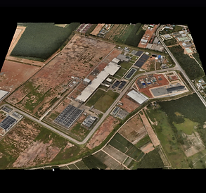
"Drone Mapping" หรือ "การทำแผนที่ด้วยโดรน" เป็นกระบวนการใช้โดรนบินเหนือพื้นที่เพื่อเก็บข้อมูลทางภูมิศาสตร์หรือภาพถ่ายมุมสูงเพื่อวัตถุประสงค์ในการวิเคราะห์หรือสร้างแผนที่ที่มีความละเอียดสูง การดำเนินการนี้อาจใช้สำหรับการวัดคุณภาพของพื้นที่การเกษตร, การวิเคราะห์โครงสร้างพื้นที่ในเมือง, การวางแผนการใช้ที่ดิน, หรือการสำรวจแหล่งทรัพยากรธรรมชาติ เทคโนโลยีโดรนได้ส่งผลให้การทำแผนที่เป็นไปได้อย่างรวดเร็วและมีค่าใช้จ่ายต่ำกว่าวิธีการสำรวจแบบดั้งเดิม นอกจากนี้ยังช่วยเพิ่มความเที่ยงตรงและความสามารถในการเข้าถึงพื้นที่ที่ยากลำบากอีกด้วย
We provide unmanned aerial vehicle (UAV) surveying services using high-quality equipment including Full Frame RGB Sensors, LiDAR YellowScan, and skilled pilots who work according to EIT Standard. Our services cover various types of drone surveys in compliance with government regulations, such as accurate mine surveying and reporting according to the announcement of the Department of Primary Industries and Mines, Stockpile volume measurement, Topographic Surveys, Geographical Area Surveys, Environmental Monitoring, and Research-oriented drone surveys, among others.
"Drone Mapping" refers to the process of utilizing drones to fly over an area to collect geographical data or high-resolution aerial imagery for analysis or high-resolution map creation. This process can be used for agricultural land quality measurements, urban structure analysis, land use planning, or natural resource exploration. The adoption of drone technology has made mapping faster and less expensive compared to traditional surveying methods. Additionally, it enhances accuracy and accessibility to difficult terrains.

ประโยชน์ของการใช้โดรนทำงานสำรวจ
-
ลดค่าใช้จ่ายอย่างมีนัยสำคัญและประหยัดเวลาได้ด้วยการใช้โซลูชั่น UAS ที่มีราคาไม่แพงและสามารถทำการเก็บข้อมูลและประมวลผลข้อมูลอัตโนมัติ
-
สามารถมองเห็นผลลัพธ์ได้อย่างชัดเจนด้วยแผนที่ความละเอียดสูงที่แม่นยำ พร้อมกับ point cloud และโมเดลสามมิติ
-
ลดความเสี่ยงต่อบุคลากรในสภาพแวดล้อมที่เสี่ยงต่ออันตรายด้วยการเก็บข้อมูลทางอากาศอย่างรวดเร็ว
-
บันทึกข้อมูลแบบดิจิทัลที่สามารถใช้ง่ายในการเปรียบเทียบการเปลี่ยนแปลงของพื้นที่โดยประจำ ทำให้ทีมสามารถตรวจสอบการเปลี่ยนแปลงได้อย่างง่ายและเชื่อถือได้ตลอดเวลา
Advantages about Drone Mapping
-
Significantly reduce costs and save time by using affordable UAS solutions that automate data collection and processing.
-
Visualize results with accurate, high-resolution maps, Point Clouds, and 3D models.
-
Reduce personnel risk in hazardous environments with switly aerial data collection.
-
Keep digital records that can be easily used for regular land cover comparisons, so teams can more easily and dynamically monitor changes.


Cadastral Survey
โดรนสำรวจที่ดิน
เพิ่มประสิทธิภาพของการบริหารจัดการที่ดินและกระบวนการที่เกี่ยวกับการเขียนสำรวจที่ดินโดยใช้โซลูชัน UAS ที่มีความแม่นยำสูงเพื่อสร้างโมเดลดิจิตอลได้อย่างรวดเร็ว
Boost the efficiency of land administration and cadastral processes by using high-accuracy UAS solutions to quickly generate digital models.
ประโยชน์ของการสำรวจที่ดินแบบประเมินภาษีที่ทันสมัย
-
โซลูชัน UAS สามารถ cover พื้นที่ใหญ่กว่าเครื่องมือสำรวจดินบนพื้นผิวดิน ซึ่งเพิ่มประสิทธิภาพในการเก็บข้อมูลในฟิลด์และลดเวลาในการเก็บข้อมูล
-
รักษาบันทึกดิจิตอลที่สามารถใช้ง่ายสำหรับการเปรียบเทียบผลการปกคลุมพื้นที่ของดินอย่างเป็นประจำ โดยทีมงานสามารถติดตามการเปลี่ยนแปลงได้โดยไดนามิก
Advantages about Cadastral Survey
-
UAS Solutions can cover larger areas than terrestrial surveying tools, improving field data collection efficiency and reducing collection time.
-
Keep digital records that can be easily used for regular land cover comparisons, so teams can monitor changes dynamically.
Solution

Portable Drone Surveying & Mapping Solution
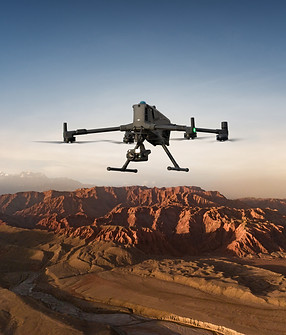
The DJI Mavic 3E is a portable surveying and mapping drone suitable for single-pilot operations. Paired with DJI Terra, it can generate accurate 2D and 3D models with significant reduction on the ground control points.
Portable solution, easy to carry and deploy.
Centimeter-level data thanks to its mechanical shutter and RTK capability.
Field-work efficiency—covers 2 km² per flight, delivering a 5cm GSD.
Real-Time Terrain Follow feature to ensure high-quality data capture in challenging and variable terrains.
Drone Platform

DJI Mavic 3E
Weight: 915 g.
Max Flight Time (no wind): 45 mins.
Sensing type: Omnidirectional binocular vision system, supplemented with an infrared sensor at the bottom of the aircraft.
Environment Adaptability: Max
Take-off Altitude Above Sea Level 6,000 m; Max Wind Speed Resistance 12 m/s.
Wide Camera: 4/3 CMOS, Effective pixels: 20 MP.
Mechanical Shutter: 8-1/2000 s,supports rapid 0.7-second interval shooting.
Compatible with RTK module and DJI Cellular module.
Payload And Software

DJI Pilot 2
Ground control

DJI Terra
Modeling and flight mission plan
Workflow
-
Data Collection: Plan a 2D, Linear Flight, or Smart Oblique Mission based on the actual landscape situation for regular orthomosaic images or oblique image data collection. Enable Real-Time Terrain Follow feature.
-
Data Processing: Import to DJI Terra to process for DOM, DSM, Point Cloud, and 3D models.
-
Data Analysis: Import DJI Terra outputs to preferred third-party software for further analysis.


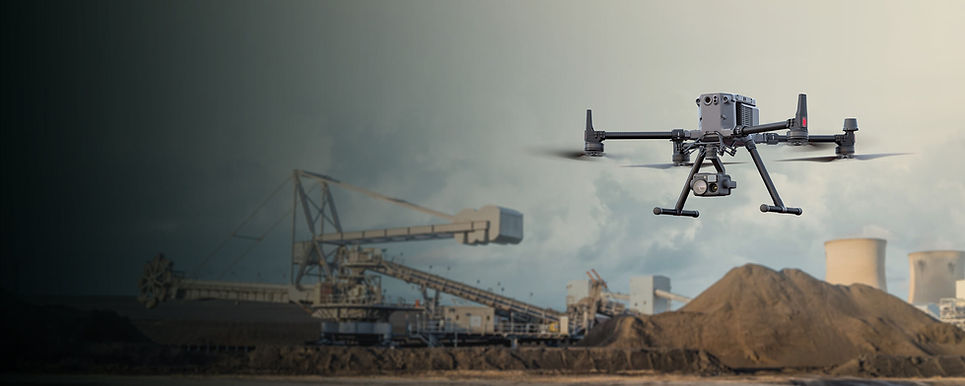
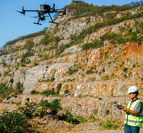
Mining Survey
โดรนสำรวจเหมือง
ปรับปรุงการวัดปริมาณสต็อกและกระบวนการจำลองหลุมด้วยวิธีการเก็บข้อมูลที่ปลอดภัยกว่า เร็วกว่า และแม่นยำกว่าวิธีการสำรวจแบบดั้งเดิม
Optimize stockpile measurements and pit modeling processes with a safer, faster, and more accurate data collection alternative compared to traditional surveying methods.
ประโยชน์ของการใช้โดรนสำรวจเหมือง
-
ครอบคลุมพื้นที่กว้างและอันตรายได้อย่างรวดเร็ว ทำให้กระบวนการเก็บข้อมูลมีประสิทธิภาพมากขึ้นและเพิ่มความปลอดภัยของบุคลากร
-
ลดต้นทุนและเพิ่มประสิทธิภาพด้วยโซลูชันการเก็บข้อมูลทางอากาศที่ติดตั้งได้ง่าย
-
ทำภารกิจเก็บข้อมูลซ้ำเพื่อรับประกันคุณภาพและความแม่นยำของข้อมูล
Advantages about Mining Survey
-
Swiftly cover vast and hazardous areas, significantly streamlining data collection process and enhancing personnel safety.
-
Reduce cost and improve efficiency with easy-to-deploy aerial data collection solutions.
-
Repeat data collection missions ensuring the data quality and accuracy.
Solution

Portable Stockpike Measurement Solution
The DJI Mavic 3E is a portable surveying and mapping drone suitable for single-pilot operations. Paired with DJI Terra, it can generate accurate 2D and 3D models with significant reduction on the ground control points.
Portable solution, easy to operate and to carry across multiple mine sites.
Reliability and high accuracy even when flying at high altitudes.
The Real-Time Terrain Following mode allows the Mavic 3E to adjust its altitude in real time, ensuring a consistent height relative to the terrain being mapped.
Drone Platform
DJI Mavic 3E
Weight: 915 g.
Max Flight Time (no wind): 45 mins.
Sensing type: Omnidirectional binocular vision system, supplemented with an infrared sensor at the bottom of the aircraft.
Environment Adaptability: Max
Take-off Altitude Above Sea Level 6,000 m; Max Wind Speed Resistance 12 m/s.
Wide Camera: 4/3 CMOS, Effective pixels: 20 MP.
Mechanical Shutter: 8-1/2000 s,supports rapid 0.7-second interval shooting.
Compatible with RTK module and DJI Cellular module.
Payload And Software
DJI Pilot 2
Ground control
DJI Terra
Modeling and flight mission plan
Workflow
-
Data Collection: Plan a 2D map mission for regular orthomosaic data acquisition or a waypoint mission for regular site video recording and pano stitching.
-
Data Processing: Import the data to DJI Terra to process for DOM, DSM, Point Cloud, and 3D model outputs.
-
Data analysis: Perform anotations, measurements and volume analysis directly in DJI Terra. Import resulting DOM, DSM or 3D models into your preferred 3rd Party software for further analysis.

โดรนสำรวจระดับมืออาชีพจาก DJI Enterprise แม่นยำ เร็ว ประหยัดต้นทุน
โดรนสำรวจระดับมืออาชีพจาก DJI Enterprise – แม่นยำ เร็ว ประหยัดต้นทุน
ในการสำรวจและทำแผนที่เชิงวิศวกรรม ความแม่นยำและประสิทธิภาพคือหัวใจสำคัญ โดรนสำรวจจาก DJI Enterprise ได้รับการออกแบบมาเพื่อตอบโจทย์งานสำรวจที่ต้องการข้อมูลละเอียดระดับเซนติเมตร ด้วยเทคโนโลยี RTK (Real-Time Kinematics) และเซนเซอร์ขั้นสูง เช่น กล้องความละเอียดสูงและ LiDAR ที่ช่วยให้สามารถเก็บข้อมูลภูมิประเทศ 3 มิติได้อย่างแม่นยำ นอกจากนี้ โดรนสำรวจยังช่วยลดเวลาในการปฏิบัติงานภาคสนาม เพิ่มประสิทธิภาพและลดต้นทุน เมื่อเทียบกับการสำรวจแบบดั้งเดิม
สำหรับงานสำรวจที่ต้องการ ความคล่องตัวและแม่นยำสูง DJI มีตัวเลือกที่ตอบโจทย์ทุกความต้องการ เช่น
-
DJI Matrice 4 Series โดรนสำรวจรุ่นใหม่ล่าสุดที่มาพร้อมกับประสิทธิภาพที่เหนือกว่า รองรับเซนเซอร์หลากหลายประเภท พร้อมการเชื่อมต่อ RTK สำหรับการสำรวจที่แม่นยำในระดับเซนติเมตร
-
DJI Matrice 350 RTK ที่รองรับเซนเซอร์ LiDAR และกล้องหลายชนิด ช่วยให้เก็บข้อมูลได้ละเอียดและแม่นยำสูงสุด
-
DJI Mavic 3 Enterprise Series ซึ่งมีขนาดกะทัดรัด แต่สามารถทำงานได้อย่างมีประสิทธิภาพด้วย กล้องซูมและ RTK ในตัว
-
DJI Zenmuse L2 เซนเซอร์ LiDAR รุ่นล่าสุดที่ช่วยให้เก็บข้อมูล 3D ได้รวดเร็วและแม่นยำ
ด้วยโดรนสำรวจ DJI Enterprise คุณสามารถสำรวจพื้นที่ขนาดใหญ่ได้เร็วขึ้น ลดข้อผิดพลาดของมนุษย์ และสร้างแบบจำลอง 3D ที่แม่นยำสำหรับอุตสาหกรรมก่อสร้าง, ผังเมือง, เหมืองแร่, เกษตรกรรม และอีกมากมาย หากคุณต้องการโดรนที่ช่วยให้การทำแผนที่เป็นเรื่องง่าย แม่นยำ และคุ้มค่ากว่าเดิม ติดต่อเราเพื่อขอคำแนะนำเกี่ยวกับรุ่นที่เหมาะกับงานของคุณ!


ขอใบเสนอราคา (Get a Quote)
ลูกค้าท่านใดสนใจบริการของทางบริษัท ไทยสกายวิชั่น จำกัด สามารถกรอกข้อมูลได้ที่ด้านล่างนี้ ทางเราจะตอบกลับท่านให้เร็วที่สุด